Cloud Types
Clouds form when air is cooled to its dewpoint or the temperature it reaches saturation.
There are four basic cloud categories observed in our atmosphere:

Cirro-form
|
High-level clouds which form above 20,000 feet (6,000 meters) and are usually composed of ice crystals. High-level clouds are typically thin and white in appearance, but can create an array of colors when the sun is low on the horizon. Cirrus generally occur in fair weather and point in the direction of air movement at their elevation. |
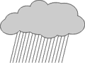
Nimbo-form
|
Nimbus comes from the Latin word meaning rain. These clouds typically form between 7,000 and 15,000 feet (2,100 to 4,600 meters) and bring steady precipitation. As the clouds thicken and precipitation begins to fall, the bases of the clouds tend to lower toward the ground. |
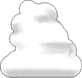
Cumulo-form
|
Clouds look like white fluffy cotton balls or heaps and show the vertical motion or thermal uplift of air taking place in the atmosphere. The level at which condensation and cloud formation begins is indicated by a flat cloud base, and its height will depend upon the humidity of the rising air. The more humid the air, the lower the cloud base. The tops of these clouds can reach over 60,000 feet (18,000 meters). |

Strato-form
|
"Stratus" is Latin for layer or blanket. The clouds consist of a feature-less low layer that can cover the entire sky like a blanket, bringing generally gray and dull weather. The cloud bases are usually only a few hundred feet above the ground. Over hills and mountains they can reach ground level when they may be called fog. Also, as fog "lifts" off the ground due to daytime heating, the fog forms a layer of low stratus clouds. |
| Cirrus Clouds (greater than 18,000 feet) |
| Cirrus |
Cirrostratus |
Cirrocumulus |
 |
 |
 |
| Cirrus clouds are the most common of the high clouds, typically found at heights greater than 20,000 feet. They are composed of ice and consist of long, thin, wispy streamers. Cirrus clouds are usually white and predict fair weather. By watching the movement of cirrus clouds you can tell from which direction weather is approaching. The appearance of cirrus clouds usually indicates that a change in weather will occur within 24 hours. |
Cirrostratus are sheet-like, high-level clouds composed of ice crystals. Though cirrostratus can cover the entire sky and be up to several thousand feet thick, they are relatively transparent, as the sun or the moon can easily be seen through them. These high-level clouds typically form when a broad layer of air is lifted by large-scale convergence. Cirrostratus clouds usually come 12-24 hours before a rain or snow storm. |
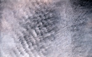
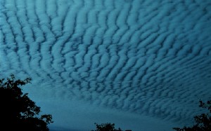
Cirrocumulus are small, rounded puffs that usually appear in long rows. They are usually white, but sometimes appear gray. Cirrocumulus are usually seen in the winter and indicate fair, but cold, weather. |
| Alto Clouds (6,500 feet to 18,000 feet) |
| Altostratus |
Altocumulus |
 |
 |
| An Altostratus cloud usually covers the whole sky. The cloud looks gray or blue-gray. The sun or moon may shine through an Altostratus cloud, but will appear hazy. An altostratus cloud usually forms ahead of storms with continuous rain or snow. |
Altocumulus clouds are grayish-white with one part of the cloud darker than the other. Altocumulus clouds usually form in groups. If you see Altocumulus clouds on a warm, sticky morning, be prepared for thunderstorms by late afternoon. |
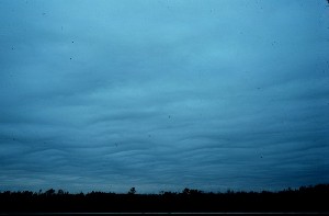
| Stratus Clouds (less than 6,500 feet) |
| Stratus |
Stratocumulus |
Nimbostratus |
 |
 |
 |
| Stratus clouds are found below 6,500 feet. They are uniform gray in color and almost cover the entire sky. Light mist or drizzle is sometimes associated with Stratus clouds. Fog results when stratus clouds touch the ground is. |
Stratocumulus clouds are low, puffy and gray. Most form in rows with blue sky visible in between. Rain rarely occurs with Stratocumulus clouds, however, they can turn into Nimbostratus. |
Nimbostratus clouds are dark gray with a ragged base. Rain or snow is associated with Nimbostratus clouds. |
| Vertical Growth Clouds |
| Cumulus |
Cumulonimbus |
 |
 |
| Cumulus clouds are puffy white or light gray clouds that look like floating cotton balls. Known for their flat bases and distinct outlines, they have a lifetime of 5-40 minutes. In fair weather, these small, lumpy clouds exhibit only slight vertical growth. The cloud tops show the limit of the rising air. Given suitable conditions, they develop vertically to become cumulonimbus associated with powerful thunderstorms. |
Cumulonimbus clouds belong to the Clouds with Vertical Growth group. They are generally known as thunderstorm clouds. A cumulonimbus cloud can grow up to 10km high. At this height, high winds will flatten the top of the cloud out into an anvil-like shape. Cumulonimbus clouds are associated with heavy rain, hail, lightning, and tornadoes. |
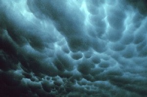
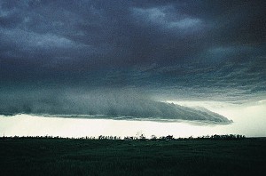
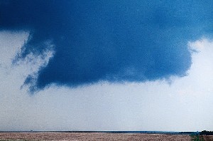
| Other Common Clouds |
| Mammatus |
Shelf |
Wall |
 |
 |
 |
| Mammatus are pouch-like cloud structures and a rare example of clouds in sinking air. Sometimes very ominous in appearance, mammatus clouds are harmless and do not mean that a tornado is about to form; a commonly held misconception. In fact, mammatus are usually seen after the worst of a thunderstorm has passed. |
A shelf cloud is a low, horizontal wedge-shaped cloud, associated with a thunderstorm gust front (or occasionally with a cold front, even in the absence of thunderstorms). A rising cloud motion often can be seen in the leading part of the shelf cloud, while the underside often appears turbulent, boiling, and wind-torn.
|
A wall cloud is associated with thunderstorms. It is a lowering of the cloud base typically beneath the rain-free portion of a cumulonimbus cloud, and indicates the area of primary and strongest updraft. Sometimes, the wall cloud will often be seen to be rotating. A rotating wall cloud is the area of the thunderstorm which is most likely to produce tornadoes, and the vast majority of intense tornadoes. |
Photography credit: NOAA Photo Library
Things to look for that indicate an approaching weather change:
- Weather changes generally come from the west/southwest so scan the sky with your weather eye, especially to the west.
- A sudden drop in temperature and change in the wind (increasing winds and/or seas) often means that a storm is near.
- A rapid drop in pressure means a storm is approaching.
- As stratus clouds lower, you will see clouds in the following order:
Cirrus >> Cirrostratus >> Altostratus >> Stratus >> Nimbostratus >> storm clouds!!
- Watch for cumulus (puffy) clouds that start to rapidly develop vertically (up) to become cumulonimbus thunderstorm clouds.
To learn more about clouds go to NASA / NOAA Cloud Chart.
|